Jan 9, 2019

HAPPY NEW YEAR 2019

HAPPY NEW YEAR 2019

it's been a year i didn't update the blog, no excuses given.

anyway for 2019, turning to 60 will be time for retirement from work and enjoy the activities that i loves to do,

this year 2019, 3 Mt Kinabalu Hike, Trail Run in Sabah and Mulu Pinnacles Adventure also to Melbourne for short holidays.

looking back the last 40 years of working , it been a journey of challenges which makes me a better man.

Choices are given but the decision we made will decide the path of our life.

M now gathering the pixs of my activities in 2018 and will post soon

Stay Healthy and Happy

Jan 15, 2018

2018 Hike Gunung Datuk

Hi

It been more than 5 months i have not updated this blog....
anyway for 2018 , look like it going to be a busy year .

confirmed 4 hikes to Mt Kinabalu and probably another one in Sept 2018 .

it will be on March, May, June, July and Sept 2018.

How many times I be going... frankly i lost counts hahhahahah

also i be busy with my own running events where last year about 9 times involving in the events.

For 2018, BHP Orange Run and Larian Hari Keputeraan Sultan Nazrin Shah are confirmed.

will be busy with hiking training and also cycling.

Every Sunday if no event, I be at MPSJ Stadium coaching special needs children (Austistics)

Below are the pixs taken at Gng Datuk in Jan 13, 2018


Aug 31, 2017

Salam Hari Merdeka Malaysia Ke 60

Salam Hari Merdeka Malaysis ke 60 to all Malaysian.

It been a while I didn't write at the blog as been busy with work and Project.

well that not the reason ya.

Ok i now resting till end Sept 2017 before starting my hiking activities as giving my knees a good rest.

At the moment it's more to cycling and organizing some running events till the end of the year.

I will updates the activities in the blog for cycling, running and hiking.

Next year will be hiking Mt Kinabalu in March and May 2018
 and also Mulu Caves adventure.

Keep healthy and smile

Feb 23, 2017

Gunung Berenbum - WW2 RAF Crash e SitNegeri Sembilan

Sunday Feb 19, 2017 cool morning at the foothill of Gunung Berenbum where 56 hikers met me to lead them to hike Gunung Berenbum

CL Chong was waiting there to join us for the group pixs and gave some pointer on Gng Berenbum. He didn't the hike as on Saturday he came down late.

The entry fee is RM5 as the Park Ranger were at the foothill.

Started to hike at 8:15am and took 45mins to reach Lata Berenbum watefall

From Lata Berembun another 1hr 30mins to Gua Kambing where the tarils are cleared and gradually upwards.

Upon reaching Gua Kambing, most of the hikers took 5 mins rest before the challenging trails to thoe peak.

300 meters up 75% with ropes tied to the trees time taken to the peak is 1hr.

From the peak to the WW2 Crash site another 1hr 15mins .

For an average hiker, average 9 hrs return hike.

Feb 14, 2017

Gng Berenbum Negeri Sembilan

Hi

It bee 5 months i didn't update as been busy and times forget anyway will be active back again.

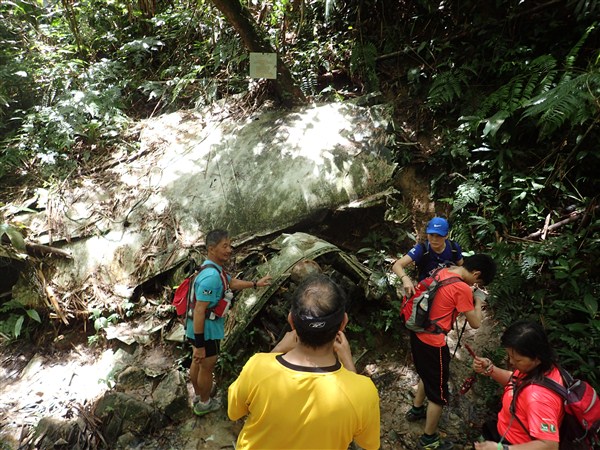
this sunday will be leading about 40 hikers to Gunung Berenbum Negeri Sembilan where the RAF WW2 Air Craft was crash.

The remnants are still there.

The trip this sunday is for the hikers joining me for Mt Kinabalu on Apr 22 and 28, 2017 and part of the training.

Will be meeting CL Chong from Ansi Hikers at the foothills and was informed the Park Rangers will be station there to collect RM5 fees.

Some if the pixs i took when i was there

Details of trip will be posted later.


Oct 18, 2016

HI

Hi it been 3 months didn't update my activities as been busy with events till now.

I planning for Mt Kinabalu hike next year , it will on Apr 22 - 25 and 28 - May 1, 2017

wah leh.. back to back.... total 70 paxs into 2 groups.

Hiking activities will start in December 2016 once all my running event over in Nov 16.

Pixs of my recent Mt Kinabalu hike


Aug 12, 2016

Gunung Santubong Kucing Sarawakr

On Aug 13, 2016, will be off to Kucing withe some of the runners for the Kucing Marathon on sunday.

I won't be running but keipo on the race day. However on Monday will lead the group to hike Gunung Santubong which is 30 mins drive from Kucing town.

It will be my 2nd hike to the Gunung.

The height of Gunung Santubong us about 810 meters. The challenging part of the trail is the rope ladders. Hikers need to be cautious.

It will take 2 -4 hours to reach teach to reach  the peak depend individual fitness level

Will post the pixs and details when i back from Kucing ..


Jul 8, 2016

Gunung Berembun Negeri Sembilan on July 16, 2016

Saturday July 23, 2016.... will be planning a hike to Gunung Berenmbun , Seremban.
This is the place where the WW2 Australian Air ForcerPlane was crashed.

The parts of the plane are still there .

will be leading the group to see the crash site and also part of Mt Kinabalu training

pixs as below take on Jan 22, 2106


Jun 23, 2016

Gunung Nuang via Ponsoon Ulu Langat

This saturday will be trekking to Gunung Nunag via Ponsoon Ulu Lnagat with some of the hikers as training for Mt Kinabalu expedition in end of August 2017.

Will not hike up to Kem Pacat but only to the end of the loggers trails and do a U turn and back to the park office.

Before reaching the Park Office will head to Ulu Ponsoon and trek there to see the old abandon hydro pump station.

Will take a breather before hike for 2 hours to a farm heading toward Janda Baik.

The whole trakking time will be about 4 - 5 hours.

Will start at Nunag Park Office 7:30am.

Will post the pixs and details next week

Jun 14, 2016

Gunung Ansi via Ulu Bendul

26 cane ad join me for the Gunung Ansi via Ulu Bendul and down by Bukit Putus last saturday on June 11, 2016,

Weather was cool in the morning and by the time we got down , it started raining.

Total hours up and down for average hiker is 5hrs 30mins.

The trails are well marked but it challenging via Ulu Bendul the 2 part of the trails .

Many thanks to CL Chong for leading the group on the 1st part of the trails.

The next hike will probably be at Ulu Bendul to see the WW2 air plane crash.


Jun 9, 2016

Gunung Ansi Seremban

It been a while i didn't trek Gng Ansi via Ulu Bendul trails.

The last few hikes were from Bukit Putus trails where is much easier as compare with Ulu Bendul trails and longer.

will be meeting up with my fellow hikers at Ulu Bendul recreational Park 8am and probably CL Chong from Gng Ansi hikers might be joining.

My younger brother Eddy and his gang will also join as part of their training to Mt Kinabalu end of July 2016

the 1st part of the Ulu Bendul trails is relatively easy as waking along the stream and also the ridge of the hills where can see the stream below. it take an hour to reach the 2nd part of the trails which is much steeper.

There will be sandy boulder and need to use ropes to climb up. from here it will take about 15mins to reach the peak.

total time from Ulu Bendul car park to peak is about 3 hours... trekking down will be via bukit putus will take an hour 30 mins...

Jun 5, 2016

Mulu Adeventure 2016

On April 28 - May 2, 2016 - Mulu Trip ... was a wet hike all the way to camp 5.

It was raining from morning till evening and the next day hike to pinnacles were aborted due to the rock surface slippery and also safety of the hikers.

We did enjoy the show caves and also the bats exodus.

Next year the trip will be end July 2017.


Gng Ansi via Ulu Bendul Trans on June 11


Will be hiking Gunung Ansi on June 11, Gunung Ansi VIA Ulu Bendul 

Start and Down via Bukit Putus.  Interesting trails, only 825meters but longer than Bukit Putus trails if you done.


There’s are 2 parts of the trails, the 1st part is walking alongside  the river, gently upwards along the ridge of the hills. The 2nd part is interesting as it will be all the upwards and before reaching the summit , there’s sandy boulders  and you need to use ropes to pull you up. It’s an open space where you can catch a breather before climbing up the boulders. From here it will take about 10 - 15mins to the summit.

Total Distance : Approximately 6.50km one way via Ulu Bendul Recreational Park but shorter via Bukit Putus going down

Usually walking pace for 6.5km will take about 1hr 30 mins, double the time when hiking up hehehheheheh

Ulu Bendul Trails : Start Elevation - 179M , Peak  Elevation – 825M

DESCRIPTION:

Gunung Angsi is the 3rd highest mountain in Negeri Sembilan, a mountain that overlooks Seremban in Negeri Sembilan, and situated along the highway to Kuala Pilah.

Coming from Seremban towards Kuala Pilah (Route 51), you will not miss the Ulu Bendul Recreational Park (on the right). Plenty of car park space.

Since most of us have hike via Bukit Putus route, this time it will be via Ulu Bendul route, slightly longer trail, interesting and starts from Ulu Bendul Recreational Forest.
Climbing Gunung Angsi via Ulu Bendul trail usually takes up to 2 - 4 hours to go up (depend on individual fitness) and coming down your choice either the same way you came up or take the Bukit Putus Trail which is much easier and faster. (You need to arrange transport to Ulu Bendul Recreational Park. Usually before heading to Ulu Bendul park , one or two cars will station at Bukit Putus so that you won’t have to walk 3km to Ulu Bendul Park)
The trail starts from the Ulu Bendul Recreation car park and walk alongside the stream at first. Certain places need to cross the stream, as the trails move inwards , a section of the trails will long and upwards along the ridge of the hill. The trails is well defined most of the way, however certain places got cross junctions, do look out for the red and white striped plastic marker tape which have been tied to trees and follow.
Another interesting about the Ulu Bendul trials, when nearing the summit, there’s some sandy boulders and you need to pull yourself up using ropes. Here it a good place to snap pictures.
====================================================================================================================
Meeting Point :  Senanwang Toll – Exit Time : 7:15am. If you know the way to Kuala Pilah, From Seremban take the road towards Kuala Pilah (route 51). You cannot miss Ulu Bendul Recreational Park (Meet here) on your right heading to Kuala Pilah . Plenty parking here. Snacks and drinks can be obtained at the park entrance but month of Ramadhan so bring your own food. 
Starting Time : 8am
Duration of Hike : 6 – 8 hours depend on individual fitness
You need to register at the park ranger's office before starting your ascent and pay a nominal fee (RM 5 per person).
Things to bring :-
a)    Water 3L – Min
b)    Food – Packed for lunch
c)     Raincoat
d)    Torch Light
e)    Trekking Poles (Optional)
f)     Whistle (Optional but recommended)
g)    Plasters
h)    Antihistamine pills – for allergy
i)      Personal belongings (wrap in zip log bag or plastics)


The Park is managed by the Negeri Sembilan Forestry Department whose contact details are:

Jabatan Perhutanan Negeri Sembilan,
Blok C, Tingkat 4,
Kompleks Setiausaha Kerajaan,
70503 Seremban,
Negeri Sembilan.


webjpnns@email.com

Phone +06-7659849
Fax +06-7623711


Apr 24, 2016

Mulu Pinnacles Apr 28 - May 2, 2016

I will away from Apr 28th - May 2, 2016 leading group of 23 paxs to Mulu Pinnacles Sarawak

all of them is their 1st time to Mulu and an adventure for them

esp the show caves, bats exodus and the pinnacles hike

About 8 paxs will not be doing the Pinnacles but trek to Melinau Gorge.